Inside #Mongolia’s ‘Mars camp’: The extreme adventure that wants to turn tourists into #astronauts.
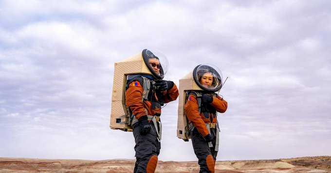
It’s Day 25. You wake up in your bunk pod in a snow-capped Martian landscape, far from civilization. Outside it’s -30 C (-22 degrees Fahrenheit). After meditating and eating a breakfast of freeze-dried dumplings, you and your six-person crew don space suits over your thermal underwear and head out into the sandstorm on a mission.
This isn’t a fever dream. It’s a month-long survival challenge deep in Mongolia’s Gobi Desert that’s designed to simulate life on Mars — for tourists.
The project, called the MARS-V Project, is under development by MARS-V, a non-governmental organization based in Mongolia’s capital, Ulaanbaatar. They’re working to build a fully-fledged Mars analogue station in the Gobi to prepare for human travel to the red planet — and expect to welcome the first tourists to the mock Mars camp by 2029.
Why Mongolia?
Nowhere on Earth mimics the geography and climate of Mars more closely than Mongolia’s Gobi. An arid, barren landscape with extreme temperature swings from 45 to -40 C (113 to -40 degrees Fahrenheit). The iron oxide-tinted soil has a reddish hue, making it look eerily Martian.
This combination of isolation, altitude and temperature is what makes the site so scientifically valuable as a training ground for scientists and astronauts — and as a test site for equipment and rovers.
For MARS-V, it also offers another potential: tourism.
“Your objective is to survive in an environment that is very, very isolated,’ says Enkhtuvshin Doyodkhuu, MARS-V CEO. “You have to have this simulation mindset that you’re on another planet: you need to feel that if you don’t follow protocol, you die.”
Surviving the simulation
Each participant will have to pass physical, psychological and mental agility tests, then undergo a three-month virtual astronaut training program on everything from oxygen protocol to the psychology of isolation.
Once you arrive in Mongolia, it’s three days of in-person drills in Ulaanbaatar with your new teammates before handing in your phone and beginning the ten-hour journey by bumpy road to the site, drifting away from civilization across stretches of pale-red dust.
“It’s surreal,” says Doyodkhuu. “This feeling of vastness, of endless empty space — the Gobi really gives you that “Mad Max” kind of feeling. It’s beautiful if you think about it, but it can be overwhelming to some.”
Your home for the month? Mars “habitats” — interconnected modular pods with living quarters, a laboratory and a greenhouse. Each day begins with the same strict daily regimen that real astronauts might face: vitamins, meditation, exercise, breakfast and a team briefing for the day ahead.
“Meditation has to be a big part of the program,” says Doyodkhuu. “One very risky thing when it comes to Mars pioneers is we don’t really know what’s going to happen with their psychology, because no other person has been away from Earth that long.”
Doyodkhuu says the Mars simulation for tourists could have a similar psychological effect.
“You’ll have this sort of claustrophobia; you’ll miss your Earth.”
Days at the MARS-V camp are filled with challenges and tasks: for example, the crew might take the rover out to conduct geological mapping or collect soil samples. Communication with “Earth” (the MARS-V mission support team) happens on a timed delay to mimic interplanetary lag. Simulations take place between October and March in brutal winter conditions, when the Gobi freezes solid.
“Minus 27 C (-16.6 degrees Fahrenheit) would be a warm day,” laughs the CEO. Crews wear thermal base layers, overalls, and analog spacesuits when working outdoors.
To make it as realistic as possible, the team from MARS-V will hide all external support out of sight.
“Compared to an Arctic expedition, this is controlled,” Doyodkhuu says. “If there was any real chance of death, we’d stop the simulation.”
Meals will feature freeze-dried Mongolian dishes — like rehydrated dumplings or mutton stews — designed to mimic astronaut rations while honoring local culture.
There’s even a design echo between the nomadic Mongolian ger — the traditional felt tent sometimes referred to as yurts — and the Martian dome prototypes being developed by the MARS-V engineering team.
“We [Mongolians] have thousands of years of history living in isolated places, with very limited resources,” Doyodkhuu explains. “We’re just taking that idea to another planet.”
Part of history
The idea of trialing planetary life on Earth isn’t new. NASA and ESA have long used analog sites for experiments and training.
But MARS-V’s plan to merge scientific research with tourism arrives at a pivotal moment: private space travel is finally edging into the mainstream. SpaceX and Blue Origin are drawing celebrities like Katy Perry, Tom Hanks and Kim Kardashian into a new era of luxury space tourism.
But, for those who can’t afford a US$28 million ticket to space, Mongolia’s MARS-V camp will offer a more accessible way to experience that cosmic allure at a fraction of the cost, expected to be around $6,000 per person for a month at the camp, and pre-camp training and evaluation.
It’s Mars tourism, without the launch cost — or the suffocating risk of decompression.
MARS-V’s analog station is in the early stages of development, with designs for the habitat, space suits and food completed. Doyodkhuu says they expect the habitats to be ready and open to the public within the next two to three years.
For those drawn to the idea of other planets, MARS-V promises a glimpse of a Martian future.
“You have a lot of time to think out there,” says Doyodkhuu. “Being in this otherworldly place for one month trying to survive with five other people, it gives you this renewed outlook on life.”
“If you believe that humans will become a multiplanetary species in the future, actually being part of this history, going to an analog astronaut training center and challenging yourself, is going to leave a big impact on people.”
For the right traveller — whether thrill-seeker, explorer or space enthusiast — it may be the ultimate holiday. But if the thought of freezing cold isolation and bunk pods sounds more like punishment than adventure, Mongolia’s Gobi already offers glimpses of the otherworldly in a far more comfortable setting.
During the summer at the Gobi’s luxury Three Camel Lodge, travellers can switch thermals for a spa towel and freeze-dried stews for an extensive whiskey selection. You will still need to strap in for the journey though, it takes 7 to 8 hours to reach the lodge from Ulaanbaatar. This is after all one of the most remote places on Earth - and perhaps the closest you can get to Mars, without leaving the planet.
By Rosanna Philpott, CNN


Space news on Umojja.com