#WASHINGTON — A defunct #military weather #satellite has broken up in orbit and created more than 50 pieces of debris, the latest in a series of similar incidents involving that line of spacecraft.

The U.S. Space Force reported Dec. 19 that it had identified a “low-velocity fragmentation event” involving the DMSP-5D2 F14 spacecraft. The event took place at 9:10 p.m. Eastern Dec. 18 at an altitude of 840 kilometers, but the announcement did not disclose how much debris had been created by the event.

Two commercial space situational awareness companies, LeoLabs and Slingshot Aerospace, said they were also tracking the breakup event. Slingshot, in a Dec. 19 social media post, said they believe the breakup took place before 8:15 p.m. Eastern on the 18th, an hour earlier than the Space Force’s estimate, based on tracking from its optical ground stations.

LeoLabs, in a Dec. 20 statement to #SpaceNews, said its network of radars was tracking more than 50 objects from the fragmentation of DMSP-5D2 F14.

The 750-kilogram satellite was launched in 1997 as part of the Defense Meteorological Satellite Program, operating in a sun-synchronous orbit. The spacecraft was retired in 2020 but remained in its sun-synchronous orbit.

DMSP-5D2 F14 is part of a family of spacecraft that have suffered breakups in orbit. The F12 satellite broke up in October 2016, following the breakup of F13 in February 2015. In 2004, the F11 spacecraft broke up, creating 56 pieces of tracked debris. All the satellites had a battery assembly with a design flaw that made them vulnerable to explosion.

A similar spacecraft design was used for a line of civilian polar-orbiting weather satellites operated by the National Oceanic and Atmospheric Administration. The NOAA-16 satellite broke up in November 2015, followed by NOAA-17 in March 2021.

Many of those satellites broke up despite going through a “passivation” process at the end of their lives, which includes draining batteries and venting fuel tanks. That process is designed to remove energy sources in a satellite that could cause it to break up long after being decommissioned.

Industry experts have noted that the passivation process may not be fully effective on some older satellites designed before orbital debris mitigation practices were enacted.


View 205 times

The U.S. Space Force is strengthening its partnership with Japan in a bid to counter China’s growing dominance in the space domain. The collaboration includes advancing shared capabilities in space object surveillance in order to track increasingly sophisticated Chinese satellites capable of dynamically altering their orbits.

Speaking at the #Spacepower Conference on Dec. 10, Brig. Gen. Anthony Mastalir, commander of U.S. Space Forces Indo-Pacific, described the bilateral relationship as entering a transformative phase following the recent activation of U.S. Space Forces-Japan, a new command stationed at Yokota Air Base in Japan. Mastalir emphasized the strategic importance of alliances in the Indo-Pacific region to “maintain peace and stability.”

“Our allies and partners recognize that a secure and accessible space domain is vital to collective defense, economic growth, and technological innovation,” Mastalir said.

The U.S. and Japan have agreed to include space within the scope of their mutual defense commitments. This means that attacks on satellites and other space-based infrastructure could trigger a collective defense response.
Collaboration on space domain awareness

At the core of the U.S.-Japan partnership is the enhancement of space domain awareness, or the capability for tracking and monitoring space objects. A joint initiative, the Quasi-Zenith Satellite System Hosted Payload (QZSS-HP) program, integrates U.S. optical sensor payloads, developed by MIT Lincoln Laboratory, into Japan’s QZSS infrastructure.

QZSS, often dubbed Japan’s version of GPS, employs geostationary satellites in inclined orbits to provide advanced navigation services across the Asia-Pacific region.

Two U.S. optical sensor payloads will be deployed aboard separate QZSS satellites, scheduled for launch in 2025 and 2026. These launches were delayed due to setbacks in Japan’s H3 rocket program.

Mastalir said these collaborations are likely to continue as China’s advanced satellite capabilities are a pressing concern for the U.S. and Japan. He highlighted the difficulties posed by Chinese spacecraft operating in non-Keplerian orbits, which deviate from classical orbital dynamics. Such orbits allow for continuous adjustments in trajectory, complicating traditional orbit determination and tracking methods.

“When we talk about space domain awareness, it’s important to get an orbit determination,” Mastalir explained. “But we also have to be prepared for spacecraft that are consistently maneuvering, making traditional tracking impossible.”

Non-Keplerian orbits provide strategic advantages, enabling satellites to achieve precise positioning and adjust coverage dynamically. This flexibility is particularly valuable for surveillance and reconnaissance missions, allowing for enhanced monitoring of areas of strategic interest. By employing these techniques, China’s satellites gain the ability to evade tracking and improve their operational effectiveness.

Mastalir said Japan has been making substantial investments in both space-based and ground-based sensor systems to address these challenges.


View 240 times

SwRI to build magnetometers for NOAA space weather #satellites .

Under the contract announced Dec. 9, SwRI will develop two magnetometers for the Lagrange 1 Series project, part of NOAA’s Space Weather Next program. The magnetometers will measure the interplanetary magnetic field carried by the solar wind. Instrument data then will be supplied to NOAA’s Space Weather Prediction Center, which issues forecasts, warnings and alerts to help mitigate space weather impacts.

SwRI’s work, scheduled to conclude in January 2034, includes design, analysis, development, fabrication, integration, test, verification and evaluation of the magnetometers. In addition, SwRI will support the launch of the instruments, supply and maintain ground equipment and assist with post-launch mission operations at the NOAA Satellite Operations Facility in Maryland.

Additional work related to the contract will be conducted in San Antonio, NASA’s Goddard Space Flight Center in Maryland and Kennedy Space Center in Florida.

NASA and NOAA will jointly oversee development, launch, testing and operation of satellites in the Lagrange 1 Series project. NOAA is providing program requirements and funding in addition to managing the program, operations, data products and disseminating data. NASA and its commercial partners will develop and build the instruments, spacecraft and provide launch services on behalf of NOAA.

San Antonio-based SwRI also is building three coronagraphs for NOAA’s Space Weather Next program and the QuickSounder weather satellite for NOAA’s Near Earth #Orbit Network.


View 228 times

#China is building on-orbit space situational awareness capabilities to navigate crowded orbits.

China’s on-orbit presence has grown dramatically in recent years, with a boom in numbers of #satellites launched, and the construction of the Tiangong space station. However, its space situational awareness (SSA) architecture heavily relies on space-based systems due to its limited global ground sensor network, according to a report from the China Aerospace Studies Institute (CASI).

The report provides new insights into China’s SSA infrastructure and outlines its unique constraints and priorities.

#China has sent at least 10 #spacecraft to low Earth orbit (LEO) for space-based SSA, according to analysis of open-source Chinese reports and literature. Further unspecified #satellites in general orbits have been referred to texts as carrying out SSA tasks.

Noted satellites include Shiyan and Shijian technology demonstration spacecraft, as well as satellites from #commercial actors Changguang Satellite Technology, operator of the Jilin remote sensing constellation, and Origin Space, a space resources firm.

The satellites use mostly optical (including infrared for detecting heat sources, especially useful when spacecraft are in Earth’s shadow, and LiDAR) and radio frequency sensors, with a variety of detection ranges.

Chinese satellites employ onboard processing for tasks like collision avoidance, aiming to reduce reliance on limited and overburdened ground stations. This autonomy enables faster response times, crucial for a nation with limited access to global relay networks. The general U.S. approach is described as relying on data analysis on the ground with human oversight.

LEO is currently the main focus of its SSA efforts due to the dense satellite population and collision risks. Less attention is set on geostationary orbit, on which the U.S. has a stronger focus.

The development of China’s space-based SSA is seen not only as having military uses and applications, but also for collision avoidance and other strategic and economic reasons. The efforts also assist China’s aim of building its own space object catalog, rather than relying on U.S. or Russian data.


View 230 times

#WASHINGTON#Slingshot #Aerospace, a space tracking and analytics company based in #California and Colorado, has been awarded a $5.3 million contract by the National Oceanic and #Atmospheric #Administration’s Office of #Space #Commerce (OSC) to design the user experience for a next-generation space traffic coordination platform.

The 12-month contract, announced on Nov. 26, includes options for four additional years, bringing the potential total value to $13.3 million.

The project, known as the Traffic Coordination System for Space (TraCSS), is a cornerstone initiative designed to modernize U.S. space traffic management and ensure the safety of civil and commercial satellites. NOAA expects TraCSS.gov, the system’s primary interface, to launch by late 2025, ahead of the scheduled migration of commercial users from the Department of Defense’s legacy space-track.org system.

“This contract award represents the next major step forward in our effort to provide spaceflight safety services to global space operators,” said NOAA Administrator Rick Spinrad. “By leveraging Slingshot’s commercial, off-the-shelf solutions, we expect to have TraCSS.gov online and ready to sign up public users by late 2025.”

Richard DalBello, Director of NOAA’s Office of Space Commerce, said Slingshot’s visualization tools “will make our technical data accessible via a modern interface reflecting the latest innovations in software and user experience design.”
Space policy shift

The TraCSS initiative emerged from Space Policy Directive-3 (SPD-3), issued in 2018, which directed OSC to take over space traffic coordination responsibilities from the DoD. The move reflects the growing commercialization of space and the need for a more user-centric platform as the number of active satellites, now exceeding 10,000, continues to rise.

TraCSS will provide tools to track satellites and debris, predict potential collisions, and enable coordinated maneuvers. These capabilities are vital in an era of increasing congestion in low Earth orbit, driven by large satellite constellations from companies like SpaceX.

The presentation layer, or user interface, designed by Slingshot, will serve as the system’s “front door.” This platform will make technical data — including conjunction warnings that help satellite operators avoid collisions — accessible through modern visualization tools.
‘Beacon’ software

Slingshot will integrate its proprietary software, Slingshot Beacon, into the TraCSS interface, enhancing capabilities for satellite operators to share information and coordinate maneuvers in real time. “Deploying the TraCSS user interface is the next major step in operationalizing U.S. civil space traffic coordination,” said Audrey Schaffer, Slingshot’s vice president of strategy and policy.

This is Slingshot’s second major contract with OSC, following an award earlier this year to provide satellite tracking data for a pilot project on low Earth orbit.

For the presentation layer, Slingshot will collaborate with system integrator T and T Consulting Services and space tracking firm COMSPOC.

Once operational, TraCSS is expected to serve a diverse range of users, from commercial satellite operators and academics to national security agencies. NOAA has emphasized the system’s global mission, aiming to improve transparency and safety across the increasingly crowded orbital environment.

Several companies have been awarded contracts for the TraCSS program:

Parsons Government Services received a $27 million contract for system integration and cloud management support services for TraCSS.
LeoLabs, Slingshot Aerospace, and COMSPOC were selected for a pathfinder project to shape TraCSS by collecting and organizing data on spacecraft and debris in orbit.
ExoAnalytic Solutions, Slingshot Aerospace, and COMSPOC won agreements to provide space situational awareness data services in low Earth orbit (LEO) and geostationary Earth orbit (GEO).
SpaceNav and Kayhan Space were selected to serve as data quality monitors for LEO and GEO observations as part of the pathfinder project.


View 243 times

HELSINKI — #China has announced a strategic roadmap for advancing its Beidou positioning and navigation system by 2035, in a move which could have global implications.

The country plans to complete key technology research for the next-generation Beidou system by 2025 and launch three test satellites around 2027, according to the “Beidou Satellite Navigation System Development Plan before 2035,” released by the China Satellite Navigation System Management Office (CNSO) Nov. 28.

The next generation of Beidou system networking satellites will then be launched around 2029. The construction of the next-generation Beidou system will be completed by 2035.

China already has a 30-satellite Beidou system providing positioning, navigation and timing services globally. It features 24 satellites in medium Earth orbits, with eight in each plane, excluding backups. There are three Beidou satellites in inclined geosynchronous orbits and three satellites in geostationary orbits.

The upgraded Beidou system will use satellites in high (likely referring to geosynchronous), medium and low Earth orbits, according to the report.

The new system will provide real-time, high-precision, and highly reliable navigation, positioning, and timing services across Earth and near-Earth spaces, with accuracy ranging from meter-level to decimeter-level, according to state media Global Times.

The system will support user terminals spanning from Earth’s surface to deep space, and integrate with other non-satellite-based navigation and timing technologies.

Beidou, like the U.S. Global Positioning System (GPS) and other systems from Europe and Russia, are used for civilian applications such as driving, aviation, and maritime navigation worldwide, as well as supporting industry, agriculture and finance. They also have military applications through precision-guided munitions, UAVs, and battlefield navigation.

Notably, the system is already widely considered to be superior to the GPS in some areas. GPS’s capabilities are already “substantially inferior to those of China’s Beidou,” according to the National Space-Based Positioning, Navigation and Timing Advisory Board (PNTAB). While Beidou has unique advantages, such as two-way communication and regional accuracy, GPS still dominates globally in terms of adoption and certain technological benchmarks.

Meanwhile, U.S. efforts to modernize GPS face delays and technical challenges, according to a Government Accountability Office (GAO) report.

An improved, next-generation Beidou could see China far surpass the U.S. and others in PNT capabilities. This could see it become the most favored system, expanding its commercial and economic influence, position China as a provider of global public goods and enhance its soft power, and provide enhanced military capabilities.

This effort aligns with China’s broader national initiative for a Space-Ground Integrated Information Network (SGIIN), which aims to merge communications, remote sensing, navigation, weather forecasting, and other satellite services into a unified system. Beidou’s integration into SGIIN would potentially enhance its utility and further solidify its role in global satellite infrastructure.

China is planning at least two low Earth orbit megaconstellations for communications, and has already built up remote sensing infrastructure in orbit through its Gaofen and Yaogan systems. China launched its first Beidou satellite in October 2000. The final pair of backup Beidou-3 satellites—the 59th and 60th launched during the program—launched on a Long March 3B rocket in September.


View 243 times

#BREMEN, Germany — China tested out a small expandable module in orbit during the recent Shijian-19 mission, an update more than a month after the spacecraft’s landing reveals.

The Shijian-19 retrievable satellite launched on a Long March 2D rocket from Jiuquan Sept. 27 and landed late Eastern Oct. 10 at the nearby Dongfeng landing site in the Gobi Desert.

The China Academy of #Space Technology (CAST), which manufactured both Shijian-19 and the test module, revealed that the “inflatable flexible sealed module” completed an on-orbit test in a Nov. 21 statement.

The module is described by CAST as a multifunctional sealed structure made from flexible composite materials. The mission was deemed a complete success by CAST, a key division of China’s state-owned contractor CASC, which also developed modules for the Tiangong space station.

#CAST stated the module is in a compressed, folded state during launch and inflates upon reaching orbit. This design offers advantages such as lightweight construction and high folding efficiency. CAST described the technology as a promising approach for constructing large-scale space-sealed modules and represents an important new direction in sealed module technology.

The company leveraged its expertise in system design, structures, mechanisms, thermal control, and space environment to achieve this breakthrough, according to the statement.

It added that ground-based tests—such as airtightness, debris impact, extreme pressure, vibration, and thermal vacuum tests—were conducted in collaboration with partner organizations to validate the module’s performance.

#China has earlier stated its interest in expandable or inflatable modules, but the Nov. 21 release appears to be the first public unveiling of related hardware.


View 261 times

#BERLIN — Blue Origin flew six people, including a pair of repeat customers and a science communicator, on the latest New #Shepard suborbital spaceflight mission Nov. 22.

The New Shepard vehicle lifted off from Blue Origin’s Launch Site One in West Texas at 10:30 a.m. Eastern. The flight lifted off on schedule without any of the countdown holds common during previous flights.

The New Shepard capsule R.S.S. First Step, making its 11th flight, landed about 10 minutes after liftoff, two and a half minutes after the booster landed, completing its 12th flight. The capsule reached a peak altitude of 107 kilometers above sea level, Blue Origin reported after the flight.

The six-person crew of NS-28 included two people who previously flew on New Shepard. Marc and Sharon Hagle, husband and wife, flew together on the NS-20 mission in March 2022, the fourth crewed flight of the vehicle.

Also on board was Emily Calandrelli, an author, television show host and online science communicator. In a social media post, she said she would become the 100th woman to go to space. That number, however, includes nine women who have flown on Virgin Galactic suborbital spaceflights that passed the 50-mile (80.5-kilometer) altitude used by U.S. government agencies for awarding astronaut wings but fell short of the 100-kilometer Kármán Line used by Blue Origin as the demarcation of space. Blue Origin, in its webcast of the launch, did not mention that milestone when discussing Calandrelli.

The other three people on NS-28 were Austin Litteral, who works in risk management in the financial industry and won his seat in a contest by an online shopping platform; James (J.D.) Russell, a technology entrepreneur; and Henry (Hank) Wolfond, chairman and chief executive of Canadian investment firm Bayshore Capital.

NS-28 with the ninth crewed flight by New Shepard and the third this year. It was also the second flight in one month after the uncrewed NS-27 flight Oct. 23. That mission was the first flight of a new crew capsule and booster that Blue Origin plans to use for future crew flights to provide “expanded flight capacity to better meet growing customer demand,” the company said at the time.


View 259 times

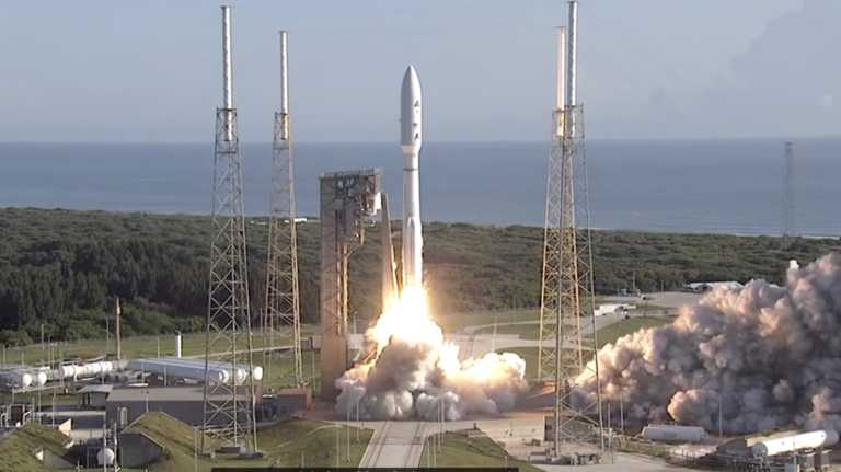
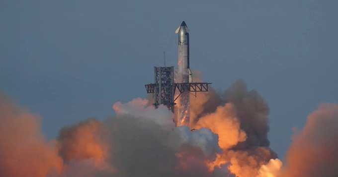
#SpaceX launches giant Starship rocket, but passes up catching it with mechanical arms.Unlike last month’s success, the booster was directed to a splashdown in the Gulf of Mexico. The catch was called off just four minutes into the test flight from Texas for unspecified reasons, and the booster hit the water three minutes later.

Not all of the criteria for a booster catch was met and so the flight director did not command the booster to return to the launch site, said SpaceX spokesman Dan Huot. He did not specifying what went wrong.

At the same time, the empty spacecraft launched from Texas atop Starship soared across the Gulf of Mexico on a near loop around the world similar to October’s test flight. Skimming space, the shiny retro-looking craft targeted the Indian Ocean for a controlled but destructive end to the hourlong demo.

It was the latest test for the world’s biggest and most powerful rocket that SpaceX and NASA hope to use to get astronauts back on the moon and eventually Mars.

SpaceX kept the same flight path as last time, but changed some steps along the way as well as the time of day. Starship blasted off in late afternoon instead of early morning to ensure daylight halfway around the world for observing the spacecraft’s descent.

Among the new objectives: igniting one of the spacecraft’s engines in space, which would be necessary when returning from orbit. There were also thermal protection experiments aboard the spacecraft, with some areas stripped of heat tiles to see whether catch mechanisms might work there on future flights. Even more upgrades are planned for the next test flight.

Donald Trump flew in for the launch in the latest sign of a deepening bond between the president-elect and Elon Musk, SpaceX's founder and CEO.

Top science and technology headlines, all in one place

SpaceX wants to eventually return and reuse the entire 400-foot (121-meter) Starship. Full-scale recycling would drive down the cost of hauling cargo and people to the moon and Mars, while speeding things up. The recycling of SpaceX’s Falcon rockets flying out of Florida and California has already saved the company time and money.

NASA is paying SpaceX more than $4 billion to land astronauts on the moon via Starship on back-to-back missions later this decade. Musk envisions launching a fleet of Starships to build a city one day on Mars.

This was the sixth launch of a fully assembled Starship since 2023. The first three ended up exploding.


View 257 times

#Satellite operator Spire Global is selling its commercial ship-tracking business to an analytics provider to invest in other data markets and its hosted payload services.

Vienna, Virginia-based Spire Global said Nov. 13 it has reached a $241 million deal to sell maritime customer contracts to Kpler of Belgium, which would also get exclusive rights to sell ship-tracking data from the operator’s satellites to commercial entities and governments worldwide.

Spire Global would retain its satellites, technology, and other infrastructure following the transaction, which includes $7.5 million for services over 12 months, as well as its current maritime customers in the U.S. government.

The proceeds would help Spire Global pay off all its outstanding debt, around $100 million worth, giving the company more financial firepower for near-term growth opportunities across its weather, aviation, radio frequency geolocation, and space services markets.

“We are now even better equipped with the resources, technology and experience to serve governments and commercial clients to fulfill their missions,” Spire Global CEO Peter Platzer said in a statement.

#Kpler CEO Mark Cunningham said the acquisition would materially improve its maritime analytics capabilities, which use space and terrestrial sensors to track #AIS — Automatic Identification Systems — transponders required on all passenger ships and most ocean-going vessels above a certain tonnage.


View 266 times